Import file
To import an existing file, click the MDTopX button and choose Import. A menu lets you choose the document type to import.
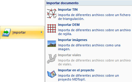
The options are:
- Import TIN: creates a TIN digital terrain model document. Supported file types are:
- USGS GTOPO30 files: grid digital terrain models from the USGS (United States Geological Survey).
- MTN 25 digital model files: grid digital terrain models stored as ASCII files, with a header describing grid properties and elevations representing grid points.
- VirtuaLand DEM files: grid digital terrain models from VirtuaLand.
- SIG del Olivo files: grid digital terrain models from TRAGSA's SIG del Olivo mapping. A dialog requests import options.
- MGE Terrain Analyst files: grid digital terrain models from MGE. A dialog requests import options.
- SRTM files: grid digital terrain models from the USGS (United States Geological Survey).
- ArcView files: grid digital terrain models from ArcView.
- INGR files: Intergraph grid digital terrain models, usually with the GRD extension. A dialog requests import options.
- Import DEM: creates a DEM digital terrain model document. Supported file types are:
- USGS GTOPO30 files: grid digital terrain models from the USGS (United States Geological Survey).
- DIGI BIN files.
- ASCII files.
- TIFF files.
- Import images.
- Import roads: imports into an active roads geometry document, which must already exist. Data stored in other formats can be added as horizontal or vertical alignments.
- Import in the project.