CAL_ORTHO
Compute orthophotographs.
Parameters
| Parameter number | Description | Optional |
|---|---|---|
| 1 | Interpolation type: 0 nearest neighbor, 1 bilinear, 2 bicubic | Yes |
| 2 | Output TIFF (Tag Image File Format) filename | Yes |
| 3 | Code of the line delimiting the orthophoto | Yes |
| 4 | Store transparency: 0 to omit it, 1 to store it. Defaults to 1 | Yes |
Supply the first three parameters together. Without them, the command asks you to select the orthophoto boundary line and opens a dialog with computation options.
Creation of Orthophotos dialog
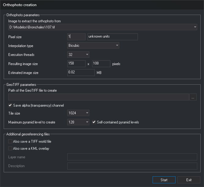
Orthophoto parameters
- Image from which to extract the orthophoto: stereo model image to project.
- Pixel size: in drawing reference system units, shown to the right.
- Interpolation type: nearest neighbor, bilinear, or bicubic.
- Execution threads: number of threads computing the orthophoto in parallel.
- Size of the obtained image and Estimated weight of the image: calculated from the selected line and pixel size.
GeoTIFF parameters
- Path to the GeoTIFF file to be created: click ... to choose the path.
- Save alpha channel (of transparency): add a transparency channel to the TIFF.
- Tile size: size of TIFF tiles in pixels.
- Maximum pyramidal level to be created and Self-contained pyramidal levels: reduced-resolution levels stored inside the TIFF. Self-contained pyramidal levels is enabled when the maximum level is not 0.
Additional geo-referencing files
- Save also a Tiff World File: generate a
.tfwfile. - Save also a superposition in KML: generate a KML file. This enables Layer name and Description.
Notes
The command requires a loaded stereo model and at least one drawing file supporting projection (such as a digital terrain model) to obtain Z for each pixel.
With parameters, it finds the first line with the specified code and computes the orthophoto without requesting data. Pixel size is AD, in drawing reference system units. The left image is the source. A .tfw georeferencing file is generated alongside the TIFF. An error message appears if the interpolation type exceeds 2 or no line has the specified code (including when the drawing is empty).
If pixel size is not greater than 0, an error message appears and no orthophoto is computed.
Command characteristics
| Command type | Interactive command without parameters; Immediate command with parameters |
|---|---|
| Repeats automatically | No |
| Menu option | Orthophoto/Create orthophoto... |
| Toolbar | This command has no associated toolbar button |
| Extension | DigiNG.OrdenesRaster.dll |
| Implementation | Native |
| Related variables | AD — active distance |
| Related commands | No related commands |
| Internal name | {47972709-ACC5-4F6E-8B04-DEB6F73554B0} |