Find gaps
Generates vector entities defining gaps in LiDAR coverage, useful for detecting water-covered areas where the laser does not return, such as ponds or swimming pools.
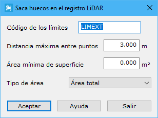
Dialog fields:
- Boundary code: code for vector entities defining detected gaps.
- Maximum distance among points: maximum neighbor distance, based on point density. Excessive values include distant points; insufficient values leave points with no related neighbors.
- Minimum surface area: regions below this area are not considered gaps. Also specify the area type.
See also:
- Find elevated points
- Find isolated points
- Find airborne points
- Find sunken points
- Find points by intensity difference
- Find points by flight line
- Find points by geometry plus RGB
- Find points by geometry plus intensity
- Find points on flat surfaces
- Find points on walls
- Find ground points only
- Magic Surface
- Find neighboring points
- Find points by infrared
- Find points by surface area
- Find points on user planes