Hypsometric tint map
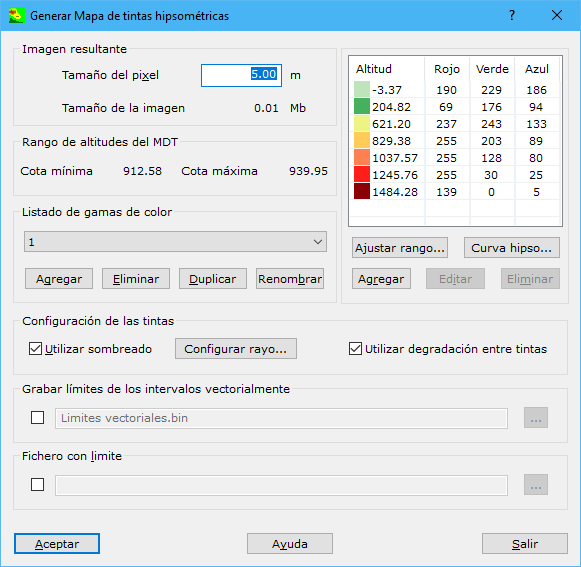
Complete these fields:
- Pixel size: pixel size in meters for the raster hypsometric tint map. Larger pixels reduce image quality, but excessively small pixels increase memory and disk requirements.
- Min height and Max height: digital model elevation limits, shown to help construct the height interval table.
- List of colour sequences: name of the color range to use. Add, delete or duplicate tables under another name for use in different files.
- Height interval table: relates colors to different heights. Add, delete or edit intervals to match the document's elevation range. Surfaces above or below this table's limits are not colored.
- Fit to range...: adjusts an interval table to user-specified elevation limits through this dialog.
- Hypso curve...: displays file surface area distribution by elevation to help design the color range.
- Use shading: combines the hypsometric tint map with black oblique shading of the digital model to show relief more realistically. See Shading.
- Ray configuration...: with Use shading enabled, configure shading in this dialog.
- Use degradation between tints: averages colors for each calculated elevation, producing transitions between color intervals. Results are visually acceptable, but colors no longer identify a point's elevation range because they are mixtures rather than pure colors.
- Save limits in vector format: records selected interval boundaries as closed vector surfaces that can be colored in another program. Use the button to the right to specify the file location. Available formats:
- DIGI: BIN extension.
- AutoCad: DXF extension.
- MicroStation: DGN extension.
- Limit file: optional file defining the hypsometric map area. Formats: DIGI BIN, AutoCad DXF, MicroStation DGN or ASCII coordinates defining the boundary. The boundary can contain one or more closed lines; ASCII supports only one line.
Requires an active triangulated digital model document.
Example
A suitable range for a file between 0 and 950 meters, combined with shading, is:
| Elevation | Red | Green | Blue |
|---|---|---|---|
| 0 | 2 | 78 | 253 |
| 10 | 1 | 44 | 26 |
| 40 | 2 | 44 | 1 |
| 80 | 89 | 111 | 2 |
| 160 | 143 | 126 | 3 |
| 280 | 145 | 77 | 2 |
| 650 | 57 | 27 | 9 |
| 850 | 56 | 12 | 10 |
| 950 | 245 | 224 | 224 |
Elevation 0 receives color 2-78-253, expressed as red, green and blue amounts; elevation 10 receives 1-44-26. Intermediate elevations receive a progressive color between these limits.
Values below 0 or above 950 meters receive no value.