Generate image
Generates a georeferenced raster document whose pixels represent a LiDAR point parameter.
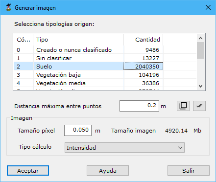
Dialog fields:
- Select source typologies: point types used to generate the image.
- Maximum distance among points: maximum neighbor distance, based on point density.
- Pixel size: pixel size in meters for the raster slope map. Larger pixels lower output quality. Match it to point spacing: smaller pixels are interpolated from surrounding points; larger pixels smooth the output image.
- Calculation type: point property represented in the output:
- Elevation: elevation, using a hypsometric color range selected in a dialog.
- RGB color: stored point color, producing a georeferenced pseudo-orthophoto.
- Intensity: recorded intensity, producing a georeferenced pseudo-panchromatic image.
- Classification: assigned LiDAR classification, using document display colors.
- Source point: measurement origin, using document display colors.
- Echo: laser return when measuring each point, using document display colors.