Ray configuration
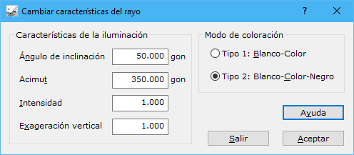
This dialog configures the ray used to generate shading, either as a map's sole relief representation or combined with hypsometric tints, aspects or slopes. Complete these fields:
- Angle of slope: ray inclination in grads. A typical inclination is 50g.
- Azimuth: ray direction azimuth in grads. To convey relief, use light from the northwest, 350g.
- Intensity: intensity proportionality factor. Use 1 for normal rays.
- Vertical exaggeration: relief proportionality factor, allowing low-height elements to be displayed and shaded.
- Colouring type: how shading is applied, with two options:
- Type 1: White-Colour: areas facing the light are white; those facing away receive their elevation color. Produces a pale image suitable for overlaying vector mapping.
- Type 2: White-Colour-Black: areas facing the light are white and those facing away are black, passing through their elevation color at intermediate orientations. Produces a dark image suitable for printing without additional mapping.