Find points by flight line
Finds and classifies points by geometric relationships with points recorded before or after them during flight. Specify classification height differences in decreasing order in the following fields.
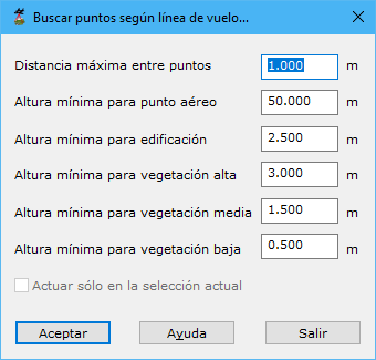
Required parameters:
- Maximum distance among points: maximum neighbor distance, based on point density. Excessive values include distant points; insufficient values leave points with no related neighbors.
- Minimum height for airborne point: minimum height above a neighbor for classification as airborne.
- Minimum height for building: minimum height above a neighbor for classification as building.
- Minimum height for high vegetation: minimum height above a neighbor for classification as high vegetation.
- Minimum height for medium vegetation: minimum height above a neighbor for classification as medium vegetation.
- Minimum height for low vegetation: minimum height above a neighbor for classification as low vegetation.
- Only in the selection: processes only currently selected points.
The program processes the current file, displaying partial results in the Results pane. Cancel asks whether to retain calculations completed so far.
See also:
- Find elevated points
- Find isolated points
- Find airborne points
- Find sunken points
- Find points by intensity difference
- Find points by geometry plus RGB
- Find points by geometry plus intensity
- Find points on flat surfaces
- Find points on walls
- Find ground points only
- Magic Surface
- Find neighboring points
- Find points by infrared
- Find gaps
- Find points by surface area
- Find points on user planes