Control point file
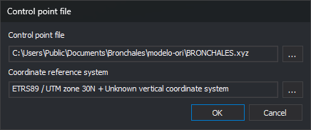
This dialog specifies the file containing ground coordinates of control points and their coordinate reference system. It is opened by ABSOLUTE_ORI, aerial triangulation measurement (AEROTRI) and the Orientation pane used by monoscopic, ADS40, orthophoto and satellite sensors:
- when starting orientation if the model has no control point file or Digi3D.AI cannot read it;
- when clicking the button to change the control point file in the orientation pane.
Fields
- Control point file: file path. Read-only: ... browses
.xyz,.pnt,.ctland.txtfiles. - Coordinate reference system: system of the file's coordinates. ... opens reference system selection.
- OK: uses the specified file and system.
- Cancel: closes the dialog. If opened when starting orientation, the command ends.
When starting orientation
- If the file cannot be read, Digi3D.AI displays an error and reopens the dialog. For absolute orientation and aerial triangulation, the error is “Warning: Unable to load control point file: file”. For generic orientation, Digi3D.AI displays “Unable to load control point file.”
- OK with an empty path ends the command.
When changing the file from the orientation pane
- If the new file cannot be read, Digi3D.AI displays an error and retains the previous file.
- In absolute orientation, if the new file lacks coordinates for any measured points, Digi3D.AI lists those points and asks “Accept a new control point file?”. No retains the previous file.
- In generic orientation, if the new file lacks a measured point, Digi3D.AI displays “Unable to locate the point: name in the loaded control point file.” and retains the previous file.