AEROTRI
Measures aerial triangulation and control points in the loaded model and saves model and photo coordinates for an aerial triangulation adjustment program.
Parameters
None.
Aerial triangulation measurement pane
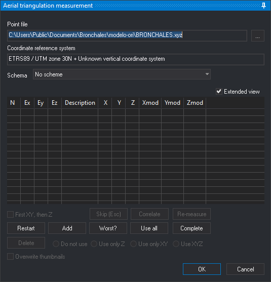
AEROTRI shows this pane and Thumbnails. AEROTRI first loads the control point file. If loading fails, Digi3D.AI displays “Warning: Unable to load control point file” and opens Control point file. Cancelling that dialog ends AEROTRI.
Uses the ABSOLUTE_ORI pane with these differences:
- Schema: aerial triangulation measurement pattern. Read from Schemas. Each point has a prefix, photo position and suffix. Its name combines prefix, photo name and suffix. The pattern applies first to the left photo, then the right. Selecting a pattern moves to the first unmeasured point and runs CORRELATE. The last pattern is remembered.
- The pane first looks for
<model name>.modin the project's Aerotriangulación folder. If<model name>.moddoes not exist, the pane looks for<left image name>-<right image name>.mod, using image names without extensions. When the pane finds a measurement file, the pane loads the saved points and disables Schema. - With no configured schema file, Schema is empty and points are measured with Add.
- An unreadable schema file displays “Error in the schema file format” and ends the command.
- The pane first looks for
- Add: opens Enter a terrain point of the point file. A name absent from the control point file is measured as an aerial triangulation point: no ground coordinates or residuals, and its use cannot change through Do not use, Use on Z, Use on XY or Use on XYZ.
- Points already measured in another model's images use their photo coordinates to position the cursor.
- After traversing the pattern, with at least two measured control points, requests control file points lying inside the model.
- OK is available even without measured points, except while remeasuring one.
OK writes in the project's Aerotriangulación folder:
- A model name.mod containing model coordinates multiplied by 1000 for both projection centers and measured points not marked Do not use.
- One photo coordinate file per photo, containing its measured points.
The pane's absolute orientation calculated from control points is used only for moving to them. Closing with OK or Cancel restores the model's absolute orientation from before the command.
Command characteristics
| Command type | Interactive command |
|---|---|
| Repeats automatically | No |
| Menu option | Photogrammetric window/Measure aerotriangulation (option added by the conical camera sensor) |
| Toolbar | This command has no associated toolbar button |
| Extension | Digi3D.ConicSensor.dll |
| Implementation | Native |
| Related variables | No related variables |
| Related commands | ABSOLUTE_ORI CORRELATE |
| Internal name | {3992CC17-D66C-4998-9B6E-FE69E0E4D4F7} |