DTM surface view
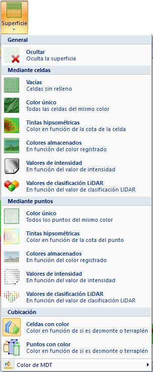
Choose among several options for displaying the digital terrain model. The current document must be a digital model or have digital models as reference files for these options to be available:
- Hide: displays no digital model graphics.
- By cells: displays the cells or triangles making up the digital model. There are three options:
- Empty: displays cells without color fill, as a wireframe. Change their color with DTM color in this list.
- One color: displays color-filled cells, giving the impression of a continuous surface as elements occlude one another. Change their color with DTM color in this list.
- Hypsometric: fills cells with color based on each constituent point's elevation. A dialog lets you choose the color range.
- RGB colors: displays DTM triangles with colors based on the colors stored for their points. Points must have colors assigned before calculating the DTM, as is common with LiDAR point clouds.
- Intensity: displays DTM triangles with colors based on their points' stored intensity values, as found in LiDAR point clouds.
- Classification: displays DTM triangles with colors based on their points' stored classification types, as found in LiDAR point clouds.
- By points: displays the points making up the digital model. There are two options:
- One color: displays colored points as a point cloud. Change their color with DTM color in this list.
- Hypsometric: displays points with colors based on their individual elevations. A dialog lets you choose the color range.
- RGB colors: displays DTM vertices with colors based on the colors stored for their points. Points must have colors assigned before calculating the DTM, as is common with LiDAR point clouds.
- Intensity: displays DTM vertices with colors based on their points' stored intensity values, as found in LiDAR point clouds.
- Classification: displays DTM vertices with colors based on their points' stored classification types, as found in LiDAR point clouds.
- Volume: if the digital model stores volume calculation values, two additional options color elements according to whether they represent cut or fill: negative or positive elevations. Fill is red, cut is green, and zero volume is blue:
- Colored cells: fills cells with the corresponding volume calculation color.
- Colored points: displays points with the corresponding volume calculation color.
- View texture: shows or hides digital model textures, both those loaded and those integrated into the digital model, without unloading them. Textures are displayed with any cell option. Available only when textures are loaded.
- DTM color: selects the color for displaying the digital model with a single color or empty cells. You can also select it using Background on the Home tab.