Ground only
Quickly finds ground points and assigns them type "2". Only points meeting that condition are classified.
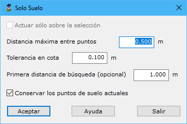
Required parameters:
- Work only on the current selection: processes only currently selected points.
- Maximum distance among points: maximum distance for points to be considered vertically aligned. Keep it small, close to LiDAR horizontal precision. Unlike other tools, it does not correspond to point density.
- Height tolerance: determines whether points belong to the same surface.
- First search distance: optional initial ground-search DTM density. Avoid very small values where large flat-roofed buildings exist.
- Keep current ground points: retains points already classified as ground.
See also:
- Find elevated points
- Find isolated points
- Find airborne points
- Find sunken points
- Find points by intensity difference
- Find points by flight line
- Find points by geometry plus RGB
- Find points by geometry plus intensity
- Find points on flat surfaces
- Find points on walls
- Magic Surface
- Find neighboring points
- Find points by infrared
- Find gaps
- Find points by surface area
- Find points on user planes