Set RGB color to points
This tool adds RGB color to each point from an external georeferenced image, either an orthophoto or a perspective image with its exterior orientation file. Useful when the laser recorded no color, adding information to improve cloud editing.
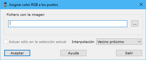
Required parameters:
- Image file: raster image supplying RGB values. It must be georeferenced with an external ORT, ORI or TFW file and can be an orthophoto or an image directly from a perspective sensor. If orientation is unavailable, calculate it with MDTopX's Orientation by measuring points. Supported formats: BMP, TIFF or JPEG. The button to the right opens Windows Explorer to locate it.
- Only in the selection: processes only currently selected points.
- Interpolation: assigns colors from nearby pixels:
- Nearest neighbor: nearest pixel value.
- Bilinear: four nearest points.
- Bicubic: nine nearest points.
See also: