Find points by infrared
Classifies points by NDVI calculated from stored infrared values. Each point must store false color composed of near-infrared, red and blue.
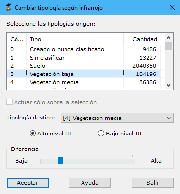
Dialog fields:
- Select source typologies: classifications to consider.
- Work only on the current selection: processes only currently selected points.
- Target type: classification assigned to points meeting the calculation conditions.
- Calculation mode: classifies by high or low NDVI. The lower slider selects a high or low difference between calculated indices. Use a high difference when false color is clear and well defined, a low difference otherwise.
- High level IR: high-NDVI points, for example reclassifying selected Building points with high NDVI as Vegetation.
- Low level IR: low-NDVI points, for example reclassifying selected Vegetation points with low NDVI as Building.
See also:
- Find elevated points
- Find isolated points
- Find airborne points
- Find sunken points
- Find points by intensity difference
- Find points by flight line
- Find points by geometry plus RGB
- Find points by geometry plus intensity
- Find points on flat surfaces
- Find points on walls
- Find ground points only
- Magic Surface
- Find neighboring points
- Find gaps
- Find points by surface area
- Find points on user planes