Project surfaces
This tool projects surfaces onto the digital model for two purposes: raising a surface above the DTM according to a centroid specifying its height difference, or generating a centroid with its relative height above the DTM.
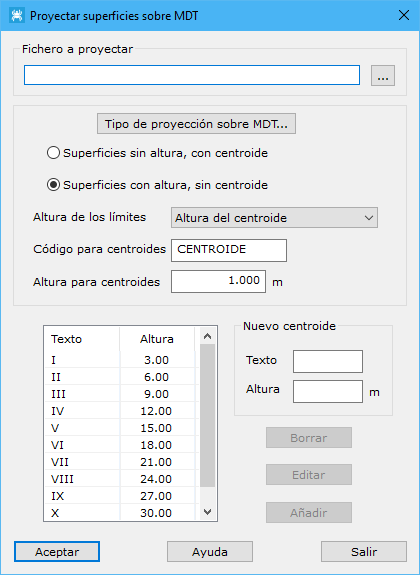
The dialog contains these fields:
- File for projection: file containing closed vector entities representing surfaces to project.
- Type of projection over DTM: how to project entities onto the DTM.
- Projection mode: two options:
- Surfaces without height, with centroid: ignores surface elevations and projects entities onto the DTM. It reads each entity's centroid and raises the surface according to its value and the list below.
- Surfaces with height, without centroid: requires elevated surfaces. Entities are projected onto the DTM, then a centroid containing the differential height is added according to the elevation difference and the list below.
- Height of the limits: four ways to determine surface elevation:
- Centroid height: projects only the centroid onto the DTM. Faster but less accurate on steep terrain.
- Maximum height: projects all entity points and uses the highest elevation.
- Minimum height: projects all entity points and uses the lowest elevation.
- Average height: projects all entity points and calculates their mean elevation.
- Centroid code: code for generated centroids.
- Centroid height: size of generated centroid texts in ground coordinates.
- Centroid list: relationship between centroid values and height above the DTM. For example, the Spanish cadastre represents each building floor with a Roman numeral. Values for below-ground floors, starting with a minus sign, and additional areas, marked with a plus sign, such as terraces or balconies, are ignored for the Spanish cadastre.
- New centroid text: adds, edits or deletes values in addition to the defaults. Specify the new centroid value and the height above the DTM it represents, in meters.
Watch video: Project surfaces onto a digital model
Requires an active triangulated digital model document.