Find points by intensity difference
Finds and classifies LiDAR points by intensity differences from their surroundings.
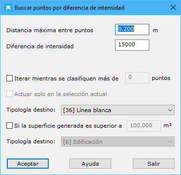
Required parameters:
- Maximum distance among points: maximum neighbor distance, based on point density. Excessive values include distant points; insufficient values leave points with no related neighbors.
- Intensity difference: signed difference between a point and its surroundings required for classification.
- Iterate while more than x points are classified: iterations may improve classification. The program repeats automatically while the classified count exceeds this minimum, stopping when it no longer does.
- Work only on the current selection: processes only currently selected points.
- Target type: classification assigned to points meeting the calculation conditions.
- If the generated surface exceeds x m2: after classifying points, the program finds surfaces to include interior points. A surface exceeding this area can receive another target classification.
- Target type: classification for points forming a surface larger than the preceding threshold.
The program processes the current file, displaying partial results in the Results pane. Cancel asks whether to retain calculations completed so far.
See also:
- Find elevated points
- Find isolated points
- Find airborne points
- Find sunken points
- Find points by flight line
- Find points by geometry plus RGB
- Find points by geometry plus intensity
- Find points on flat surfaces
- Find points on walls
- Find ground points only
- Magic Surface
- Find neighboring points
- Find points by infrared
- Find gaps
- Find points by surface area
- Find points on user planes