Moving the photogrammetric window to a cadastral reference
You can move the photogrammetric window to the centroid of a parcel in Spain's Cadastre using its cadastral reference. Digi3D.AI queries the Cadastre web service for the centroid's coordinates, so an Internet connection is required.
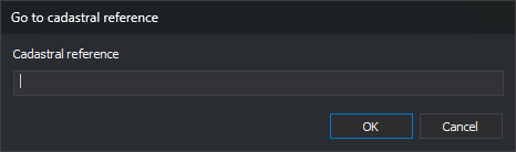
- Open Photogrammetric window and select Go to cadastral reference...
- The Go to cadastral reference dialog appears.
- Enter the cadastral reference in Cadastral reference.
- Click OK.
- The photogrammetric window moves to the parcel centroid's X and Y coordinates and retains the current Z.
Details
- Only the reference's first 14 characters, which identify the parcel, are used. You can enter a property's full 20-character reference.
- The model's coordinate reference system cannot be local. If it is, Digi3D.AI displays a message stating that the active coordinate system must be supported by the Cadastre web services, and the window does not move.
- If the model's horizontal system has an EPSG code, Digi3D.AI requests the centroid in that system. If the Cadastre does not support the code and responds in a different system, Digi3D.AI displays the same message and the window does not move.
- If the horizontal system has no EPSG code, for example because it comes from a .prj file without an authority, the Cadastre returns the centroid in the parcel's ETRS89 UTM zone, and Digi3D.AI uses those coordinates without transforming them.
- If the Cadastre returns an error, for example because the reference does not exist, Digi3D.AI displays the error text and the window does not move.
- The connection uses the Internet communication settings in Configuration: a direct connection or the Windows proxy settings.