Aspect map
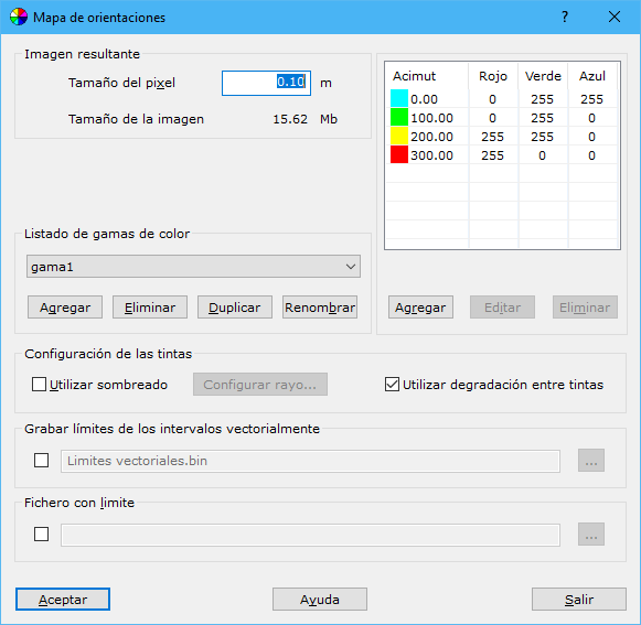
Complete these fields:
- Pixel size: pixel size in meters for the raster aspect map. Larger pixels reduce image quality, but excessively small pixels increase memory and disk requirements.
- Range name: color range name. Add, delete or duplicate tables under another name for use in different files.
- Azimuth interval table: relationship between colors and azimuth ranges. Add, delete or edit intervals. Azimuths are in grads.
- Use shading: combines the aspect map with black oblique shading of the digital model to show relief more realistically. See Shading.
- Ray configuration: with Use shading enabled, configure shading in this dialog.
- Use color gradients: averages colors for each calculated aspect, producing transitions between color intervals. Results are visually acceptable, but colors no longer identify a point's aspect range because they are mixtures rather than pure colors.
- Save interval boundaries as vectors: records selected interval boundaries as closed vector surfaces that can be colored in another program. Use the button to the right to specify the file location. Available formats:
- DIGI: BIN extension.
- AutoCad: DXF extension.
- MicroStation: DGN extension.
- Boundary file: optional file defining the area for the aspect map. Formats: DIGI BIN, AutoCad DXF, MicroStation DGN or ASCII coordinates defining the boundary. The boundary can comprise one or more closed lines; ASCII files support only one line.
Requires an active triangulated digital model document.